Maas - Mosel - Saar - Mit Rhein-Marne-Kanal bis Straßburg
NUOVO
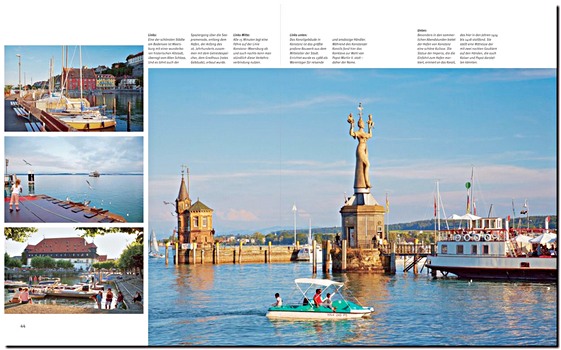
Scoprite le vie navigabili della Mosa, della Mosella e della Saar - fiumi che attraversano Germania, Francia, Belgio, Lussemburgo e Paesi Bassi. Collegano villaggi vinicoli romantici, castelli medievali e paesaggi impressionanti. La guida fluviale di Manfred Fenzl è il compagno ideale per esplorare queste acque interne.
La sesta edizione rivista fornisce tutte le informazioni nautiche essenziali per una navigazione sicura e piacevole. Gli itinerari coprono la valle della Mosella, della Saar, della Mosa e il canale della Marna al Reno.
Comprende:
- Ponti, chiuse, livelli dell'acqua, soste e punti di rifornimento
- Informazioni legali per la nautica da diporto e canali VHF
- Consigli per imbarcazioni trasportate su rimorchio, con varo e campeggi
Con 150 illustrazioni e 135 carte a colori, la navigazione diventa semplice. Dalla Mosella tra Nancy e Coblenza, alla Mosa e al suo canale, o al circuito della Saar - questa guida garantisce crociere fluide e sicure. Una guida indispensabile per pianificare e vivere viaggi indimenticabili sulle acque interne d'Europa.
Dettagli del libro
| Autore: | Manfred Fenzl |
|---|---|
| Formato: | 272 pagine, 24.5 x 18 x 2.5 cm, copertina rigida |
| Illustrazioni: | 150 foto in colori, 135 mappe in colori |
| Lingua: | tedesco |
| Editore: | Edition Maritim (D, 2025) |
| ISBN: | 9783667122728 |