When you order through the buttons on this page, we may earn a small commission at no extra cost to you. Learn more >

Cruising guides - Germany: rivers and canals

A guide for your boating holiday in Germany (rivers and canals)? Here are cruising guides and directions that inform you about navigation and marinas.

Inland Waterways of Germany (Revised First Edition)

This is the only comprehensive directory to the entire navigable German waterway system available in English. After a general introduction to the area, details of German formalities and cruising notes, each river and canal is described in detail and supported by a table of distances indicating locks, bridges, mooring places and other features.
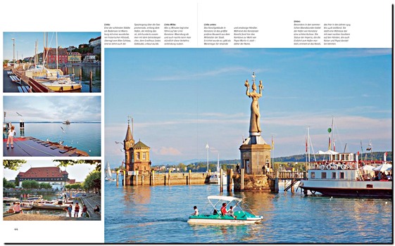
The text is supported by small scale mapping and colour photographs.

Barry Sheffield's first edition of this book was published in 1995 shortly after the reunification of Germany. He had spent several years exploring the navigable waterways and, with the assistance of Konrad Nussbaum, the acknowledged expert on German rivers and canals, he produced this authoritative work on the subject.
Barry Sheffield died some years ago and this revised edition has been produced as a result of many contributions from users of the original book. Catherine and John Best have completely recompiled many of the original tables, brought information up to date and supplied excellent new photographs.
Robert Thomas has contributed a more general update, in particular to the introductory sections.

Product details

Author:Barry Sheffield, Catherine Best, John Best
Details:183 pages, 30 x 21.5 x 1.9 cm / 11.8 x 8.5 x 0.75 in, paperback
Illustrations:numerous colour photos and maps
Publisher:Imray, Laurie, Norie & Wilson Ltd (GB, 2016)
ISBN:9781846234637
Book: Inland Waterways of Germany (Revised First Edition)

Inland Waterways of Germany (Revised First Edition)

Language: English

Buy on Amazon.com
Buy on Amazon UK
Buy on Amazon CA

Maas - Mosel - Saar - Mit Rhein-Marne-Kanal bis Straßburg

NEW

Explore the waterways of the Meuse, Moselle, and Saar - rivers flowing through Germany, France, Belgium, Luxembourg, and the Netherlands. They connect romantic wine villages, medieval castles, and striking landscapes. Manfred Fenzl's cruising guide is the perfect companion for boaters exploring these inland waters.
The sixth revised edition offers all essential nautical details for a safe and enjoyable journey. Routes cover the Moselle Valley, the Saar, the Meuse, and the Rhine-Marne Canal.

Includes:
- Bridges, locks, water levels, moorings, and supply points
- Legal information for recreational boating and VHF channels
- Tips for trailer boaters, including slipways and campsites

With 150 illustrations and 135 color maps, navigation is made easy. From the Moselle between Nancy and Koblenz, to the Meuse and its canal, or the Saar loop - this guide ensures smooth and safe cruising. An indispensable guide for planning routes and unforgettable river journeys across Europe.

Product details

Author:Manfred Fenzl
Details:272 pages, 24.5 x 18 x 2.5 cm / 9.7 x 7.1 x 0.98 in, hardback
Illustrations:150 colour photos, 135 maps in colour
Publisher:Edition Maritim (D, 2025)
ISBN:9783667122728
Book: Maas - Mosel - Saar - Mit Rhein-Marne-Kanal bis Straßburg

Maas - Mosel - Saar - Mit Rhein-Marne-Kanal bis Straßburg

Language: German

Buy on Amazon.com
Buy on Amazon UK
Buy on Amazon CA

Binnentouren Deutschland: Die 23 schönsten Touren

NEW

Germany's inland waterways offer ideal routes for boating holidays, with protected natural areas, gentle hills, historic towns, and vibrant cities waiting to be explored. Whether planning a day trip or a longer summer journey, this guide provides everything in one volume.

It presents 23 varied route suggestions, from short trips to multi-week cruises. Each includes practical details such as bridge clearance heights, locks, harbours, and more.

Travel past castles along the Moselle, relax in East Frisia, or visit Berlin's city centre by boat. The guide supports trip planning with maps, regulations, and information on water depths, river widths, bridges, and overnight moorings.

Covered waterways: Danube, Neckar, Lahn, Moselle, Rhine, Saar, Main, Havel, Elbe, Müritz, Spree, Mittelland Canal, Ems, Coastal Canal, Kiel Canal, and Weser.

Product details

Author:Frank Koorneef
Details:224 pages, 24 x 16.5 x 2.2 cm / 9 x 6.5 x 0.87 in, paperback
Illustrations:233 photos, 24 maps
Publisher:Delius Klasing Verlag GmbH (D, 2024)
ISBN:9783667128331
Book: Binnentouren Deutschland: Die 23 schönsten Touren

Binnentouren Deutschland: Die 23 schönsten Touren

Language: German

Buy on Amazon.com
Buy on Amazon UK
Buy on Amazon CA

Der Bodensee

Lake Constance is one of the largest inland lakes in Germany and the third largest in Central Europe. It offers ideal conditions for sailing and boating. This harbour guide by Daniel Knopp covers the entire Lake Constance region across Germany, Austria, and Switzerland.

It provides detailed descriptions of all ports, including aerial views, harbour plans, and approach tips. In addition to navigation advice, it includes information on the local weather warning system and the Bodensee boat licence. Recommendations for hotels, restaurants, and services help with planning longer trips.

The revised edition covers all parts of the lake - Obersee, Untersee, and Überlinger See - and gives insights into the region's cultural and natural highlights. The guide also offers background on the area's history and practical suggestions for shore excursions and family-friendly sailing.

Whether travelling with a private berth or on a chartered boat, this guide is a practical companion for exploring Lake Constance.

Product details

Author:Daniel Knopp
Details:244 pages, 30.5 x 21.5 x 2.5 cm / 12 x 8.5 x 0.98 in, hardback
Illustrations:211 photos, 83 maps
Publisher:Delius Klasing Verlag GmbH (D, 2023)
ISBN:9783667122131
Book: Der Bodensee

Der Bodensee

Language: German

Buy on Amazon.com
Buy on Amazon UK
Buy on Amazon CA

Von Berlin zur Müritz - Mit Mecklenburger Kleinseenplatte

A nautical guide from Berlin to the Mecklenburg Lake District. The route from Berlin to the Müritz is short - this sailing guide helps navigate the waterways of one of Central Europe's most beautiful inland regions. It provides information on waters, marinas, and moorings, including service and supply options. Detailed maps and photos support safe navigation.

Key contents:
- All navigable waterways from the Havel-Oder waterway to the Rheinsberg lakes
- Orientation aids for an unforgettable water tour
- Tips for sights and scenic stops
- Information on boat fuel stations and services

The unique canals, rivers, and lakes make the journey to the Müritz a destination in itself. Peace and nature accompany the route from the lively capital to the lake district, ensuring a relaxing boating holiday.

Product details

Author:Bodo Müller
Details:96 pages, 25 x 18.5 x 1.5 cm / 9.8 x 7.3 x 0.59 in, hardback
Illustrations:53 colour photos, 26 maps in colour
Publisher:Delius Klasing Verlag GmbH (D, 2023)
ISBN:9783667121820
Book: Von Berlin zur Müritz - Mit Mecklenburger Kleinseenplatte

Von Berlin zur Müritz - Mit Mecklenburger Kleinseenplatte

Language: German

Buy on Amazon.com
Buy on Amazon UK
Buy on Amazon CA

Der Rhein - Vom Rheinfall bis zur Nordsee und zum IJsselmeer. Neckar bis Heidelberg und Lahn bis Limburg

From the High Rhine to the Netherlands: the Rhine and its tributaries offer diverse options for boating holidays. Whether a weekend trip along the vineyards or a longer journey to the IJsselmeer, careful planning is essential.

The 9th edition of the trusted inland waterway guide by Manfred Fenzl provides all necessary information for a relaxed Rhine tour. The compact guide covers all sections of the Rhine - from the Rhine Falls at Schaffhausen to the North Sea in the Netherlands - and its tributaries: High Rhine, Upper Rhine, Middle Rhine, Lower Rhine, Neckar to Heidelberg, Lahn to Limburg, Gelderse IJssel, and Maas.

Detailed river maps with distances, locks, bridge heights, fuel stations, slipways, and moorings make navigation easier. Numerous photos and short texts about each waterway provide clear guidance for planning and orientation.
With this guide, leisure captains have all the information needed for safe and enjoyable boating trips on the Rhine at a glance.

Product details

Author:Manfred Fenzl
Details:208 pages, 30 x 21.5 x 2.2 cm / 11.8 x 8.5 x 0.87 in, hardback
Illustrations:140 maps
Publisher:Edition Maritim (D, 2022)
ISBN:9783667121608
Book: Der Rhein - Vom Rheinfall bis zur Nordsee und zum IJsselmeer. Neckar bis Heidelberg und Lahn bis Limburg

Der Rhein - Vom Rheinfall bis zur Nordsee und zum IJsselmeer. Neckar bis Heidelberg und Lahn bis Limburg

Language: German

Buy on Amazon.com
Buy on Amazon UK
Buy on Amazon CA

Die Donau: Von Kelheim zum Schwarzen Meer

A boat trip on the Danube offers the opportunity to explore some of Europe's most beautiful cultural and natural regions from the water. As one of the longest rivers in Europe, the Danube crosses ten countries and provides recreational boaters with a wide range of experiences along its 2.800 kilometres.

Melanie Haselhorst and Kenneth Dittmann have travelled the river several times and share their knowledge in this compact guide, intended for those planning their own boating trips.

This Danube guide contains practical information for a safe and enjoyable journey. Clear river maps show key navigation points and support orientation on inland waters. Helpful tips from the authors and detailed marina and mooring plans assist with arrival and docking.

A general information section explains the river's navigation conditions, specific features, and gives advice on suitable boat equipment. The guide also includes suggestions for excursions and sightseeing along the river.

Whether you prefer quiet cruising in nature or visiting lively cities along the Danube, this guide helps you prepare for your journey.

Product details

Author:Melanie Haselhorst, Kenneth Dittmann
Details:328 pages, 24.5 x 18 x 2.7 cm / 9.7 x 7.1 x 1.06 in, hardback
Illustrations:396 photos, 177 maps
Publisher:Delius Klasing Verlag GmbH (D, 2022)
ISBN:9783667121721
Book: Die Donau: Von Kelheim zum Schwarzen Meer

Die Donau: Von Kelheim zum Schwarzen Meer

Language: German

Buy on Amazon.com
Buy on Amazon UK
Buy on Amazon CA

Planungskarte Wasserstraßen Deutschland Nordost: Elbe bis Oder - Mit Berlin und den mecklenburgischen Gewässern

From the Saale to the Baltic Sea: Northeast Germany's rivers, canals and lakes offer diverse routes for boating holidays. Highlights include the Müritz, the Mecklenburg Lakes and the Berlin Spree.
The 7th edition of this trusted inland waterway guide provides a color planning map at 1: 375.000 scale plus a clear companion booklet. Both short trips and longer tours can be planned easily and safely.

The booklet lists locks, water depths, bridge clearances, moorings, fuel stations and traffic restrictions. It covers all navigable waterways of northern and eastern Germany, including the Elbe Lateral Canal, Müritz-Elde Waterway and the Spree.
With more than 200 color maps and detailed nautical information, navigation is reliable throughout the region. The spiral-bound booklet is practical for use on board.

Whether a weekend outing on the Elbe or a longer holiday on the Mecklenburg Lake District - this set is the perfect aid for all boating trips in northeast Germany.

Product details

Author:Bodo Müller
Details:48 pages, 24.5 x 19 x 1.2 cm / 9.7 x 7.5 x 0.47 in
Illustrations:23 colour photos, 200+ maps in colour
Publisher:Edition Maritim (D, 2022)
ISBN:9783667121592
Book: Planungskarte Wasserstraßen Deutschland Nordost: Elbe bis Oder - Mit Berlin und den mecklenburgischen Gewässern

Planungskarte Wasserstraßen Deutschland Nordost: Elbe bis Oder - Mit Berlin und den mecklenburgischen Gewässern

Language: German

Buy on Amazon.com
Buy on Amazon UK
Buy on Amazon CA

Vom Rhein zur Nord- und Ostsee - Flüsse und Kanäle zwischen Rhein, Ems und Elbe

With a motorboat through northern Germany: Between the Rhine, Ems, Elbe and the North and Baltic Seas lies a wide network of well-developed waterways. Now in its 9th edition, this proven guide offers a complete overview of all major rivers and canals.
More than 200 color maps and numerous photos support navigation, supplemented by practical information on locks, bridge heights, fuel stations, moorings and supplies.

The waterways described include the Rhine-Herne Canal, Dortmund-Ems Canal, Mittelland Canal, Weser, and the Elbe with Hamburg, Magdeburg and Cuxhaven, as well as the Coastal Canal, Elbe Lateral Canal, Elbe-Lübeck Canal and Kiel Canal.
With helpful tips and information on excursions ashore, this guide is the perfect companion for relaxed boating holidays on northern Germany's inland waterways.

Product details

Author:Manfred Fenzl
Details:290 pages, 25 x 18.5 x 2.3 cm / 9.8 x 7.3 x 0.91 in, hardback
Illustrations:269 colour photos, 190 maps in colour
Publisher:Edition Maritim (D, 2022)
ISBN:9783667121202
Book: Vom Rhein zur Nord- und Ostsee - Flüsse und Kanäle zwischen Rhein, Ems und Elbe

Vom Rhein zur Nord- und Ostsee - Flüsse und Kanäle zwischen Rhein, Ems und Elbe

Language: German

Buy on Amazon.com
Buy on Amazon UK
Buy on Amazon CA

Deutschland Nordwest: Rhein - Elbe - Ems - Weser. Mit Mittellandkanal

Reliable maps are essential for boating in Germany. More than 7.000 kilometers of navigable canals and inland waterways are available. The "Northwest Germany Waterways Planning Map- (7th edition) provides all key information for safe journeys from the Rhine to the north.

Covered waterways:
- Rhine (from Wiesbaden)
- Dortmund-Ems Canal
- Mittelland Canal
- Coastal Canal
- Fehn region
- Weser
- Elbe Lateral Canal
- Elbe
- Kiel Canal

The map shows all navigable routes from the Dutch to the Danish border, including locks. The companion booklet adds practical data on depths, bridge clearances, fuel stations, and traffic rules. An alphabetical index ensures quick reference.
With this planning map and detailed nautical notes, every trip can be safely prepared - whether to the North Sea or the Baltic.

Product details

Author:Jürgen Straßburger
Details:56 pages, 24.5 x 18.5 x 1 cm / 9.7 x 7.3 x 0.39 in, spiral binding
Illustrations:illustrated, 1 kaart in colour
Publisher:Edition Maritim (D, 2021)
ISBN:9783667122735
Book: Deutschland Nordwest: Rhein - Elbe - Ems - Weser. Mit Mittellandkanal

Deutschland Nordwest: Rhein - Elbe - Ems - Weser. Mit Mittellandkanal

Language: German

Buy on Amazon.com
Buy on Amazon UK
Buy on Amazon CA

Hausbooturlaub Mecklenburgische Seenplatte

The Mecklenburg Lake District, Europe's largest inland waterway area, offers perfect conditions for a houseboat holiday. Lakes, rivers and canals lead through varied landscapes and cultural sites. As boats can be rented without a license, the region is especially attractive for beginners.

This practical guide presents ten routes for houseboats and two extra tours for floating homes. It covers major waters such as Müritz, Lake Kölpin and Lake Schwerin, as well as the Great Lakes, the Müritz-Elde Waterway, the Small Lakes and the Upper Havel.

The guide includes:
- detailed route descriptions with maps
- information on harbors, moorings, locks and bridges
- tips on supplies, leisure activities and sights
- advice on chartering and preparation

It combines nautical details with background information on places of interest, excursions and dining options.
A reliable companion for exploring the "Land of a Thousand Lakes."

Product details

Author:Christine Lendt, Jens Rademacher
Details:180 pages, 22 x 12 x 1.2 cm / 8.7 x 4.7 x 0.47 in, paperback
Illustrations:134 photos, 15 maps
Publisher:Delius Klasing Verlag GmbH (D, 2021)
ISBN:9783667120625
Book: Hausbooturlaub Mecklenburgische Seenplatte

Hausbooturlaub Mecklenburgische Seenplatte

Language: German

Buy on Amazon.com
Buy on Amazon UK
Buy on Amazon CA

Planungskarte Wasserstraßen Berlin: Potsdam bis Scharmützelsee. Mit Havel, Spree und Kanälen

Boat tours in Berlin: discover the capital from the water. Whether cruising the government district on the Spree, passing under the Landwehr Canal bridges, or relaxing on Müggelsee, Berlin's waterways offer something for everyone.

The 5th edition of the popular planning map with companion booklet provides all essential information for safe and easy navigation. The two-page color folding map at 1: 65.000 scale shows all navigable rivers, lakes, and canals from Potsdam in the west to Scharmützelsee in the east, and from Tegel Lake in the north to the Teupitz waters in the south.
The spiral-bound booklet includes details on locks, depths, fuel stations, moorings, and local regulations. It helps with route planning and ensures a relaxed tour.

With map and booklet, you are perfectly prepared for any boat trip in and around Berlin - from weekend excursions to longer journeys.

Product details

Author:Jürgen Straßburger
Details:48 pages, 24.5 x 18.5 x 1 cm / 9.7 x 7.3 x 0.39 in, spiral binding
Illustrations:22 colour photos, 1 kaart
Publisher:Edition Maritim (D, 2021)
ISBN:9783667121615
Book: Planungskarte Wasserstraßen Berlin: Potsdam bis Scharmützelsee. Mit Havel, Spree und Kanälen

Planungskarte Wasserstraßen Berlin: Potsdam bis Scharmützelsee. Mit Havel, Spree und Kanälen

Language: German

Buy on Amazon.com
Buy on Amazon UK
Buy on Amazon CA

Planungskarte Wasserstraßen Deutschland Süd: Rhein, Main, Mosel, Donau, Neckar, Bodensee

From Lake Constance to central Germany: Southern Germany's waterways offer varied options for boating holidays. Whether short trips on the Moselle or longer journeys on the Rhine, Neckar, Main or Danube, careful planning is essential.

The 6th revised edition of the trusted planning map shows all navigable waterways and locks from the German-Swiss border to central Germany. The large 1: 440.000 scale allows easy planning of longer tours.
The companion booklet provides essential nautical information such as depths, bridge clearances, lock times, fuel stations, regulations, and traffic restrictions. All rivers and canals shown on the map - including Lake Constance, Rhine, Neckar, Main, Main-Danube Canal, Danube, Lahn, Moselle, and Saar - are clearly listed.

With map and booklet, leisure captains have all the information needed for safe and relaxed boating in southern Germany at a glance.

Product details

Author:Jürgen Straßburger
Details:28 pages, 24.5 x 18.5 x 0.9 cm / 9.7 x 7.3 x 0.35 in, spiral binding
Illustrations:17 colour photos, 1 kaart in colour
Publisher:Edition Maritim (D, 2021)
ISBN:9783667121622
Book: Planungskarte Wasserstraßen Deutschland Süd: Rhein, Main, Mosel, Donau, Neckar, Bodensee

Planungskarte Wasserstraßen Deutschland Süd: Rhein, Main, Mosel, Donau, Neckar, Bodensee

Language: German

Buy on Amazon.com
Buy on Amazon UK
Buy on Amazon CA

Mosel - Von der Quelle bis zur Mündung

The ancient poet Ausonius sang about it two thousand years ago in his "Mosella", and other writers were also impressed by the river landscape of the Moselle in one way or another: while Goethe probably found his emotional "Werther style" in Ehrenbreitstein, Tucholsky sneered at the imperial monument at the "Deutsches Eck", which had the "ornamental measles".
From here Hanns-Josef Ortheil undertook his "Moselreise" to Trier. Sophie von La Roche's literary salon was just as important for the cultural history of the Moselle as the "reading societies" in Koblenz and Trier.

The smaller - and perhaps more important - stories, however, took place in the villages and towns between the source at the Col de Bussang and the mouth of the Rhine. Karl Marx's parents had their vineyard here on the Ruwer, and Günther Jauch currently has his here on the Saar. The vineyards along these two rivers belong to the famous Mosel wine-growing region, which is home to numerous renowned wineries.

This book takes you on a river trip from the source in the southern Vosges through the fascinating valley meanders with the steep vineyard terraces to the mouth of the Rhine at the Deutsches Eck in Koblenz. The urban highlights such as Metz in France, Schengen in Luxembourg or Trier, Traben-Trarbach and Cochem are shown in detail.

Product details

Author:Brigitte Merz, Erich Spiegelhalter, Michael Kühler
Details:160 pages, 30 x 24 cm / 11.8 x 9 in, hardback
Illustrations:229 colour photos
Publisher:Stürtz Verlag (D, 2020)
ISBN:9783800344901
Book: Mosel - Von der Quelle bis zur Mündung

Mosel - Von der Quelle bis zur Mündung

Language: German

Buy on Amazon.com
Buy on Amazon UK

Der Dortmund-Ems-Kanal - 265 Kilometer Wasserstraße von A bis Z

The Dortmund-Ems Canal is the middle section of the network of waterways between the Rhine and the Elbe. It connects the largest canal port in Europe - Dortmund - with Emden's seaport on the North Sea, once Germany's ore and coal port for the Ruhr region. But "coal to the mountain and ore to the valley" is long gone. The canal has had to reinvent itself again and again, was expanded, rebuilt and rerouted.

This book, which follows on from the volume on the Mittelland Canal, portrays the Dortmund-Ems Canal in a factual and multifaceted way and offers - rounded off by a detailed chronicle - sober information as well as entertaining, sometimes surprising stories.

Product details

Author:Bernd Ellerbrock
Details:276 pages, 22.5 x 24.5 x 2.5 cm / 8.9 x 9.7 x 0.98 in, hardback
Illustrations:400 b&w and colour photos
Publisher:DGEG Medien GmbH (D, 2017)
ISBN:9783946594116
Book: Der Dortmund-Ems-Kanal - 265 Kilometer Wasserstraße von A bis Z

Der Dortmund-Ems-Kanal - 265 Kilometer Wasserstraße von A bis Z

Language: German

Buy on Amazon.com
Buy on Amazon UK
Buy on Amazon CA

Der Rhein - Von den Schweizer Alpen bis zum Mündungsdelta

World-famous cities such as Strasbourg, Cologne, Düsseldorf and Rotterdam are located on the banks of the Rhine, as are Konstanz on Lake Constance, Schaffhausen at the Rhine Falls and Speyer, Worms and Mainz with their important cathedrals.
Wine in particular characterizes the natural and cultural area of the Rhine. In addition to the Kaiserstuhl in Baden and the Rheingau and Rheinhessen, it is above all the steep slopes of the Middle Rhine Valley that contribute to the fame of the fine wines.

Over 175 images show world-famous sights on Europe's great river as well as lesser-known gems.

Pages of the book Der Rhein (1)

Product details

Author:Brigitte Merz, Erich Spiegelhalter, Alexander Eckardt
Details:140 pages, 30 x 24 cm / 11.8 x 9 in, hardback
Illustrations:175 colour photos
Publisher:Stürtz Verlag (D, 2017)
ISBN:9783800342020
Book: Der Rhein - Von den Schweizer Alpen bis zum Mündungsdelta

Der Rhein - Von den Schweizer Alpen bis zum Mündungsdelta

Language: German

Buy on Amazon.com
Buy on Amazon UK
Buy on Amazon CA
< >

Related titles:

The Baltic Sea and Approaches (4th Edition)

The Baltic Sea and Approaches (4th Edition)

RCC Pilotage Foundation | English | hardback | 376 p. | 2017

Germany and Denmark

Germany and Denmark

RCC Pilotage Foundation, Nicholas Hill | English | paperback | 272 p. | 2022

Reviere von oben – Rügen mit Hiddensee

NEW

Reviere von oben - Rügen mit Hiddensee

Siegrun Scheiter, Bodo Müller | German | spiral binding | 120 p. | 2025

Törnführer Nordseeküste 1 - Cuxhaven bis Den Helder

NEW

Törnführer Nordseeküste 1 - Cuxhaven bis Den Helder

Jan Werner | German | paperback | 272 p. | 2024

Törnführer Ostseeküste 2 - Wismar bis Stettin

NEW

Törnführer Ostseeküste 2 - Wismar bis Stettin

Jan Werner | German | paperback | 232 p. | 2024

Törnführer Ostseeküste 1 - Travemünde bis Flensburg

Törnführer Ostseeküste 1 - Travemünde bis Flensburg

Jan Werner | German | paperback | 192 p. | 2021

Törnführer Nordseeküste 2 - Elbe bis Sylt

Törnführer Nordseeküste 2 - Elbe bis Sylt

Jan Werner | German | paperback | 238 p. | 2017